A big thanks to fellow thru-hiker VirGo for filming my presentation at the Mazamas in Portland in January 2017. Now you can watch it here:
A big thanks to fellow thru-hiker VirGo for filming my presentation at the Mazamas in Portland in January 2017. Now you can watch it here:
I wrote this post a few weeks ago but didn’t get around to posting it till now. Lots of options for short trips along the ODT. Another post coming soon about my recent ski tour in the Steens!
Early March…
I spent the last 2 days visiting a few of the trail towns along the Oregon Desert Trail, meeting with businesses and several folks from the Forest Service and BLM. On my way down I was able to connect with Kyle, an ODT hiker who had first left Bend in January about 2 months ago. We’ve had a crazy snow year, and when he left he was on snowshoes and pulling a sled. It was slow going through the snow and by the time he made it to Paisley, was suffering from the strain of an unusual gait due to the snowshoes, so took a month off to heal and ended up working for a bit at the Summer Lake Hotsprings. Not a bad place to rest up and watch the snow fall!
He just happened to be getting back on the trail the day I was passing through, so I picked him up and took him to breakfast in Paisley. A big order of biscuits and gravy later, I was dropping him off at the Chewaucan Crossing so he could start again.(update, the snow and mud had Kyle rethinking his hike, he’ll be back in the fall to finish the ODT)

It’s really feeling like spring, and while there is plenty of snow still in the mountains, I think he will have a much easier time of it now, spring is right around the corner.
I had a GREAT series of meetings in Lakeview, and came away excited by the town’s eagerness for recreation. I think big things may be happening here!
I made my way out to Plush, driven by memories of an awesome burger that Dave, the owner of the Hart Mt Store, had fixed for me last summer. I was just in time for lunch and Dave was at the grill again. I’m feeling lucky! Sounds like there are some new lodging options for hikers, so I was really glad I had made the trip to check in.
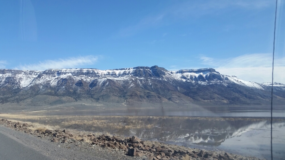
The day was freaking beautiful and warm, I could practically see the snow melting off the mountains around me. Hart Mountain was looking mighty fine, so I decided to drive up to the refuge and see if the road to the hotsprings was open. I had planned to spend the weekend somewhere on the trail and brought skis and my backpacking gear so I could have more flexibility.
I arrived at the refuge headquarters to find the road closed due to wet muddy conditions, but it was still open to hikers, so I loaded my pack up and headed in the 5 miles intending to camp at the hotsprings campground.
The day was so warm I took off my fleece for my sunshirt, and even then still had some sweatyness. Oh how I’ve missed the sun and warm weather!!! There is still quite a bit of snow on the landscape, but it made for dramatic views as I walked away the afternoon.
The campground was slumbering under patches of snow, but I found some dry ground to set up my tent, and headed to the hotsprings for a soak. What luxury to have this place all to myself!
Tomorrow I’ll head out and see if I can find a place to ski in the Warner Mountains, and maybe the day after try to climb up the 2,500’ lift of Abert Rim. So many options out here!!
I had the opportunity to share some tips with the Hiking Project about preparing for a desert hike. Check it out!
How to Prep for a Long-Distance High Desert Hike
Cold winter days and long, dark nights are the perfect time to start planning your next adventure.
We sat down with Renee Patrick, Oregon Desert Trail coordinator for the Oregon Natural Desert Association (ONDA), to get some tips on pre-hike prep. Renee has hiked nine long-distance trails and racked up over 10,000 miles on some of the popular trails—and brand-new routes all over the country.

Renee Patrick | Photo courtesy of ONDA
How should someone start planning for a thru-hike?
I like to start by reading a journal or five from someone who has hiked the trail I’m interested in. The websites Trailjournals and Postholer have thousands of journals from long trails all around the world. Next, head to the website of the organization that maintains or manages your trail, and download or buy the resources they have available. On routes like the Oregon Desert Trail or Grand Enchantment Trail, it is especially useful to do a lot of research as there are many more factors to consider on a route that may be unmarked, have long distances between water sources, or contain a lot of cross-country travel.
How does planning for a route differ from planning for a trail?
The biggest difference probably comes in honing some of the skills you will need on a route. Having solid navigation skills is a must. Even with great GPS-based resources like the Hiking Project that can be used on a smartphone in the backcountry, know that electronics can fail or break. It’s extremely important to always carry paper maps and a compass. If you aspire to hike a route but don’t have those navigations skills dialed in yet, consider taking a class at your local REI or check out an online tutorial. Then practice, practice, practice.

Navigation skills are a must. Photo courtesy of ONDA
Water is next. Many of the popular desert routes out there (Oregon Desert Trail, Hayduke Trail, Grand Enchantment Trail) and even some of the trails (Pacific Crest Trail, Arizona Trail) can’t be done without caching water [read: hiding water along your route] ahead of time. Sometimes helpful “trail angels” will cache water for hikers, but unless you place your own water out in the desert, it’s best not to rely on public caches. A caching strategy is key. We’ve developed some caching guidelines to help hikers figure out some best practices, but your water needs could vary drastically from the next person. You will have to do some math. Look at the water resources available, (many routes and trails have a water chart that lists sources, reliability, and location), calculate the distances between reliable sources, and based on your estimated daily average, you should be able to figure out where and how much water to cache.
It’s important to know that the season you choose for your hike could drastically impact water availability and needs. Plan to pack all of your caches out as you reach them. Plastic gallon jugs of water are easy to crush or cut up so you can fit them in your pack.
How do you plan for what gear you’ll need?
Each trail or route will have a different set of challenges, and therefore a different set of gear needs. On desert trips, a sun umbrella could make the experience much more pleasant. Keeping the sun off your head and shoulders while walking can save your skin and keep you much cooler. An umbrella works great in the rain or snow, too.
Look at the temperature and projected weather. If you are hiking in July, you probably don’t need your 20-degree sleeping bag and can take a lighter and smaller bag. Likewise, if hiking in the fall, temperatures could get very cold, so having extra layers or a shelter that can withstand an early snowfall is a good idea. If you think you’ll be hiking in the rain, go hike in the rain. If you think you’ll be hiking in the snow, go hike in the snow. Use your gear, do a test run or two, and make sure all your systems are a go before you find yourself in the middle of the backcountry.
https://www.instagram.com/p/BPgJyKjA8xB/embed/?cr=1&v=7
How do you plan out a resupply strategy?
Some trails and routes have compiled a list of towns and resources you can expect to find along the hike. These resources are a great place to start.
Once you have your estimated mileage figured out (it’s always best to underestimate how many miles you can hike during the first few weeks), and know the distance between trail towns, you can then look at the resources available in those towns. For example, the Oregon Desert Trail has a few stops where a hiker could not buy enough food to last a week on the trail. In that case, it’s a good idea to send a resupply box ahead of time or put together a box in a larger town and mail it ahead to the smaller town. I really like this last strategy as I often don’t know how many miles I’ll be hiking a day, especially along a route where there is a lot of cross-country travel.
Always send your resupply boxes via priority mail, as they can be forwarded on at no charge if your plans change (and it only takes two to three days for delivery). Don’t be afraid to make some calls to find out what is available if the resources are lacking.
https://www.instagram.com/p/BQON1LiggH1/embed/?cr=1&v=7
Planning for stove fuel is another big resupply issue. Many small towns might not have canister fuel or white gas. I have been using a wood burning stove recently, and love that I don’t have to figure out how to ship or find fuel along the trails anymore.
Any other advice?
A great resource is another hiker. If you can find someone locally who has hiked the trail you are interested in, take them out for a beer and pick their brains. You never know what wisdom will emerge after an IPA or two!
Following an incredible first year on the job MAKING A TRAIL (still a dream job after a year!), I wrote this letter for some papers in the high desert. It’s no joke, the people I meet on the way are a huge reason why I hike. We may be a divided country on a lot of fronts, but it always seems like we have lots in common when you meet a stranger in the backcountry and start telling stories.

I floated past Ron and his grandson Gavin on my packraft trip in the Owyhee this July
Successful Season on the Oregon Desert Trail
I’ve lived in Oregon for over 12 years, and have enjoyed spending time hiking, packrafting, and exploring the public lands of the high desert. This year I spent almost seven weeks walking across Eastern Oregon along the 750-mile Oregon Desert Trail. In addition to the wildlife, wildflowers, and incredible desert skies, I encountered countless acts of generosity from the people I met along the way. From a handful of fresh cherries, to a ride back to my car, and ice cold water on a hot July day, these gifts from chance encounters are a big reason I love putting on a pack. I can’t think of a better way to learn about a place than to share a beer and a story or two with someone, and hear about some of their favorite places to explore.
Four other hikers completed the entire route this year in addition to countless others who spent a day or two hiking in the desert; they all had similar stories of generosity and chance encounters. All were safe and successful in navigating the route in what is a series of trails, old two-track roads, and cross country hiking. It’s a challenging route as there are no physical markers on the ground, but that didn’t deter those backcountry navigators from enjoying and exploring the high desert.
Thank you to all in Bend, Christmas Valley, Summer Lake, Paisley, Lakeview, Plush, Adel, Frenchglen, Fields, Denio, McDermitt, Rome and Adrian, and all those in between.
—Renee Patrick, Oregon Desert Trail Coordinator

Cover image: Wildhorse Lake embodies the incredible beauty of wild places in Eastern Oregon. All images by Renee Patrick
Since I began backpacking 14 years ago, I have hiked through more national forests, wilderness areas, national parks, and tracts of BLM than I can count…literally over 10,000 miles worth of public lands. But their worth has only recently been on my mind. I guess you could say I have taken for granted that the United States is incredibly rich in wild places.
Public Melting Pots
I’ve seen clues…the long distance trails are a melting pot of cultures from foreign countries. Many of those hikers come to the U.S. because of the lack of public lands in their home countries. Their wild lands are gone, developed, extracted, or patchworked so that one could not walk 2,000 continuous miles for months on end in a space that has been created for the trees, elk, butterflies, rivers and recreation.
Oregon Desert Trail
Since starting to work on establishing the Oregon Desert Trail with the Oregon Natural Desert Association (ONDA) last year, I’ve begun to pay closer attention to public lands. ONDA has been working for 30 years to protect, defend, and restore the land in Eastern Oregon, and the Oregon Desert Trail passes through some of the most spectacular areas east of the Cascade Mountains. Not all of these lands are equal; not all are managed for wildlife or river health, or recreation. I’ve learned there are many layers to the puzzle of public land throughout Oregon and the country.
Why does this matter?
No Guarantees
Because there’s no guarantee the land we currently love to explore will be open to us next year, or in perpetuity. Our modern culture of wants and desires do have an impact on the world around us; consumption on a global scale does impact where we get our lumber, minerals for technological devices, and oil to fuel the cars we love to road trip in.
And those resources come from the land. So the question becomes, where is it appropriate to extract versus protect? If we extract too much or cause environmental damages (intentional or not), we can destroy the very land that sustains us and our wildlife and way of living.
Economic Impacts
If we protect everything from development and extraction, the cost of those goods and services can go up; it impacts those who make a living from timber harvest, mining, or drilling. It’s not an easy answer; it’s not an easy question. But since working to build a 750-mile route through Eastern Oregon, I’m ready to tackle the hard questions.
Our land management agencies are trying to strike a balance between extractive practices and protective measures…that balance strives for sustainability, but is often difficult to manage for all purposes out there…even recreation.

After 5 sections and over 6 weeks, Renee finished the entire Oregon Desert Trail.
Multi-Purpose Management
Working to build this route provides an opportunity to learn about the different layers of public land management: what influences it, what threatens it, what happens if pieces don’t get protected… if they do…it’s given me the chance to know a place on a much deeper level than I ever considered before when my main concern was getting to Canada before the snow falls.
Public land is essential for outdoor recreation, and while my recreation has been a relatively personal experience in the past, now I have the opportunity to help facilitate recreation experiences for a much bigger audience: hikers, ultrarunners, boaters, bikers, horseback riders, snow shoers, skiers…the list goes on.
Be The Change You Wish To See
I love the saying “We must be the change we wish to see in the world,” and for my part I wish to better educate myself on public lands, and want to help others to do the same. Through understanding, I believe we can better care for and steward our special places.

The Steens Mountain Wilderness became the first cow-free wilderness in the United States in 2000
I plan to explore these layers of land management by using the Oregon Desert Trail as a guide. As one hikes, bikes or paddles across Eastern Oregon, the maps, guidebook, and companion materials can be a tool to understand the different landscapes, their importance in the ecological diversity of the area, and the ways in which they are managed.
Speak Up
We all have a say in the future of public land, I believe the first step is through exploration and adventure in these wonderful and wild places…the next is through education.
Here’s the continuation of my conversation with Rudy at Cascade Hiker Podcast focused on the Oregon Desert Trail…give a listen!

Rudy Giecek has been a supporter of Hikertrash for a while, that’s how we first got acquainted, and he’s been producing the Cascade Hiker Podcast recently. He asked me to be a part and here’s the first episode about my hiking experiences.
Next week I’ll be talking more about the Oregon Desert Trail.
Thanks Rudy!
Wow, what a journey this year! I’m sitting in my hotel room in Fields making hitch sign in hopes of getting a ride to Frenchglen where my car is parked. Of course that will happen after I devour a breakfast worthy of a hiker that has been on the trail much longer than I have.

I’ve never section hiked a trail before, and loved dabbling in the different mountains and canyons of eastern Oregon during 3 different seasons. From when I started in May, it has been over 5 months and 5 different trips to pick away at the miles.
Immersing myself in the hike, and the job, and in supporting other hikers has felt like a great coming together of all my past experiences; I have never felt so incredibly engaged on every level. and there is so much to do! So many other areas to explore, connections to make, and hikers to tell about this route.
I has a great realization recently…I went to grad school for museum exhibition design…a field I’ve never actually worked in besides my internship at the Smithsonian years ago. But at the heart of my desire to design three dimensional spaces to share an idea or artwork or knowledge, is facilitating an experience. The more interactive and immersive…appealing to all senses, the better. My exhibit has become the desert of Eastern Oregon.
The trail is an introduction to a landscape, and through maps and guidebooks and research into the incredibly rich history, geology, land management, and wildlife, I feel like the information the trail has the ability to impart is endless. Walking for weeks in the immense sagebrush seas and craggy fault block mountains, soaking in the numerous hotsprings, eating at the small cafes, and meeting folks who have homesteaded out here since the westward expansion is facilitating an experience much larger and deeper than I ever could have in a museum.
Dude.
I’ll leave you with one of my first video experiences talking about the trail. Ultrarunner Christof Teuscher has been producing a video series, about his 17 day, 15 hour run of the entire 750 miles this summer! and stay tuned for some upcoming podcasts by Cascade Hiker Podcast where I talk about the ODT and hiking.
Ahhh, I woke with another soak in the hotsprings this morning. I made myself a cup of french press as is custom, and saw the first glimmers of light from the massive desert sky. I didn’t linger though, cause I knew I had over 20 miles to hike today, and I wanted to get to my ending point of Fields before the store closed at 6pm.
I was hiking by 7, and had a quick stop at Frog Springs which would be my only potable water for the day. Most of the water around here is too alkali, brackish, or has high levels of arsenic. Good idea to pay attention to the water report around here folks!
I walked on dirt roads for most of the morning, and then had some cross country sections that had me wishing for pants. Whatever it is that looks like sagebrush but pointier, feels like a thousand sharp needles. Ouch.
Lunch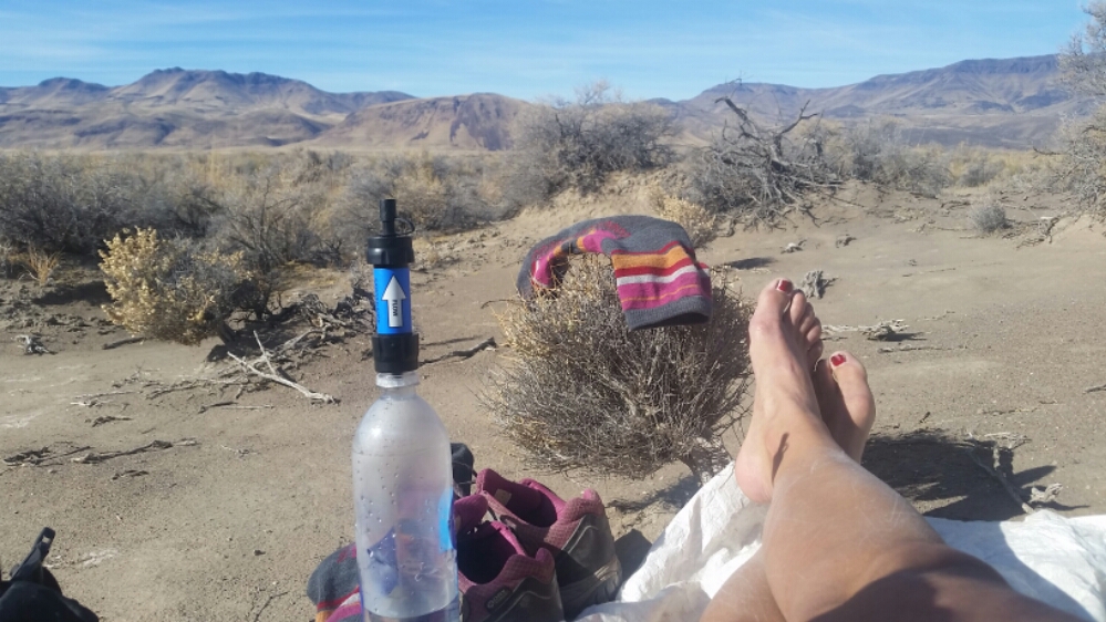
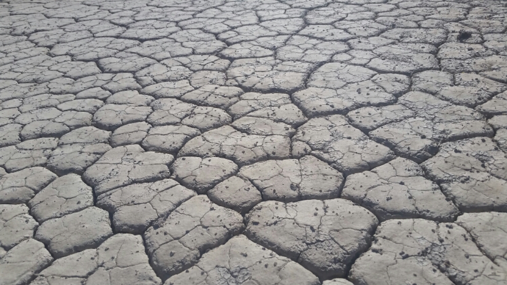
I was on the playa and getting close to Alvord Lake. Cool sand and mud formations started popping up, and a white crust started coating the ground. At one point I started walking on the dry lakebed, and saw numerous tracks of ATVS that had done the same….but it had rained since the summer, and I sank into mud in places. I had several muddy streams to cross and I started to worry about quicksand, not knowing if that was a thing around here.
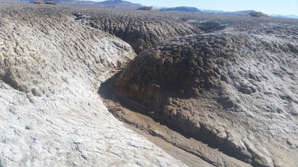
The patterns in the desert earth were infinitely interesting, and I loved the hike despite worrying about getting sucked down into the ashy alkali mud.
I knew I was approaching Borax hotsprings when the earth’s crust turned whiter and I could start to see steam rising from the countless scalding pools. These pools are too hot and temperamental to soak in, and it was here that I decided to skip up to Frenchglen back in June because I had blisters the size of small children on my feet.
I was back! Back at the scalding pools of arsenic water, and that only meant one thing! I had finished the Oregon Desert Trail!
Well, almost. I was still over 6 miles from anywhere, but fortunately I had booked a room at the Fields Sation and had a few hours to get there before the store closed.
6 miles takes forever when you are done with a thing, but texting and instagram helped pass the time. That and some Pandora.
When I got to Fields I order a beer and a round for anyone who wanted one. I only had one taker, but had a great time chatting with Sandy, Nancy and my domestic beer drinking new friend.
I missed the last call for the grill, but Sandy offer to microwave something for me, so I grabbed a frozen dinner and burrito to take to my room. Celebration time!
I didn’t sleep well, actually I don’t think I slept at all. I don’t know why my body does to me. And i knew I had a big day ahead of me, climb 2,000 feet up to the top of the Steens which appeared to have snow, and then drop down 5,000 feet to the Alvord Desert with some gnarly bushwacking.
I saw the impending snowy wall get bigger as I hiked up, I was nervous my route might have a lot of snow, but the closer I got the more doable it seemed. I still had some ice and snow to contend with, it was mearly my snail pace that kept me plugging along.
When I got to the top, it wasn’t the top. Just kidding! There were a few false summits and by this time I was either walking on crusty snow, or slogging through drifts of a few inches. Still ok since I’m used to snow travel, but I wouldn’t recommend hiking this in November to many people. I had a few miles on the Steens Loop road where I got to see down to the desert below, so stunning!
As I approached the trail to Wildhorse Lake I was nervous the snow and steep trail wouldn’t be passable. It was getting icy and i had to walk through increasingly deep snow drifts, but I knew the trail was south facing so hoped the snow would at least be soft.
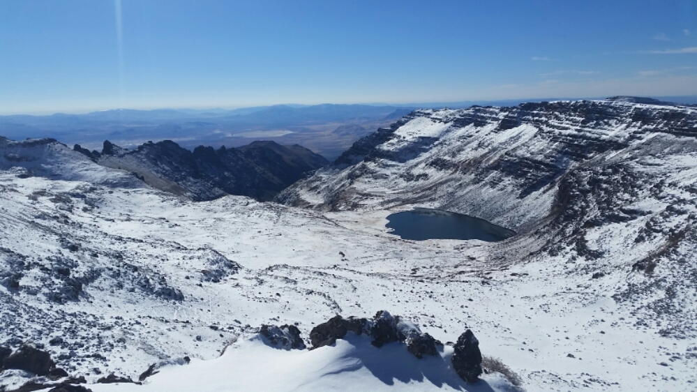
The first 5 steps were the worst and I kicked steps in. I could see the trail covered with snow, but there was a lot of rock showing, so I was reassured I could get myself down. It was after noon by this point and the snow was nice and soft. Yes!!
By the time I made it the the lake’s outlet I wasn’t feeling so hot. I think I had been driving myself hard this morning, and barely eaten anything, hadn’t drank enough water and was going on no sleep, so I took the next hour and lay down on some rocks…there was still snow all around. I couldn’t eat, which isn’t a good sign, but drank some drink mix and closed my eyes. I was starting to doubt I could make it another 10 miles down to the desert, but I finally got up and tried.
The first bit I descended open terrain and passed several waterfalls, but after a while the bushwacking got intense. Fireweed this summer had some particularly rough words for this section and I echoed her sentiment. It got even worse and couldn’t tell where I was supposed to navigate around some huge rock formations and lots of loose dirt. I just didn’t get this part…will have to see if anything else makes sense here. I finally saw the big cairn that marked my last pass; remnants from the 1980s Desert Trail route. Soon I was cruising on a dirt road. Man, there is nothing like some intense bushwacking to make you appreciate a dirt road! I was feeling much better and was able to eat my lunch at an earlier break.
Where am I supposed to go????
I flew down the road, and at Tuffy Creek took a road that wasn’t on my map down to the Alvord Hot Springs. It was after dark when I got there and was thrilled to find soda and chips for sale. Electrolights and salt!!
I checked in for a campsite and chatted with Rose the caretaker for a while. Then set up my tarp, ate some mac and cheese and went for a soak in the hotsprings. Bliss!!!!!!!!!
