Corvallis to the Sea Trail: Day 2 – 17.5 miles (36.5 total)

The rain started overnight, but was very considerate and stopped while we were packing up camp. We were out and hiking at first light…that means 7:30ish these days. Daylight savings starts tomorrow, but we’ll still follow the sun’s lead, not some arbitrary number on a watch.

Amber cut that tree

We started down a section of trail that Amber had helped clear before and found a few more logs for her to come back and address with her chainsaw. The forest was dripping with rain, but flashes of blue sky still teased us from above…this would be the general pattern of the day.

Umbrellas up, Umbrellas down, rain coats on, raincoats off. We made progress and periodically had views back towards Mary’s Peak….a hiker on the C2C could summit Mary’s Peak if they wish…we did not wish, so kept moving. 

Thank you rainbow
So dramatic

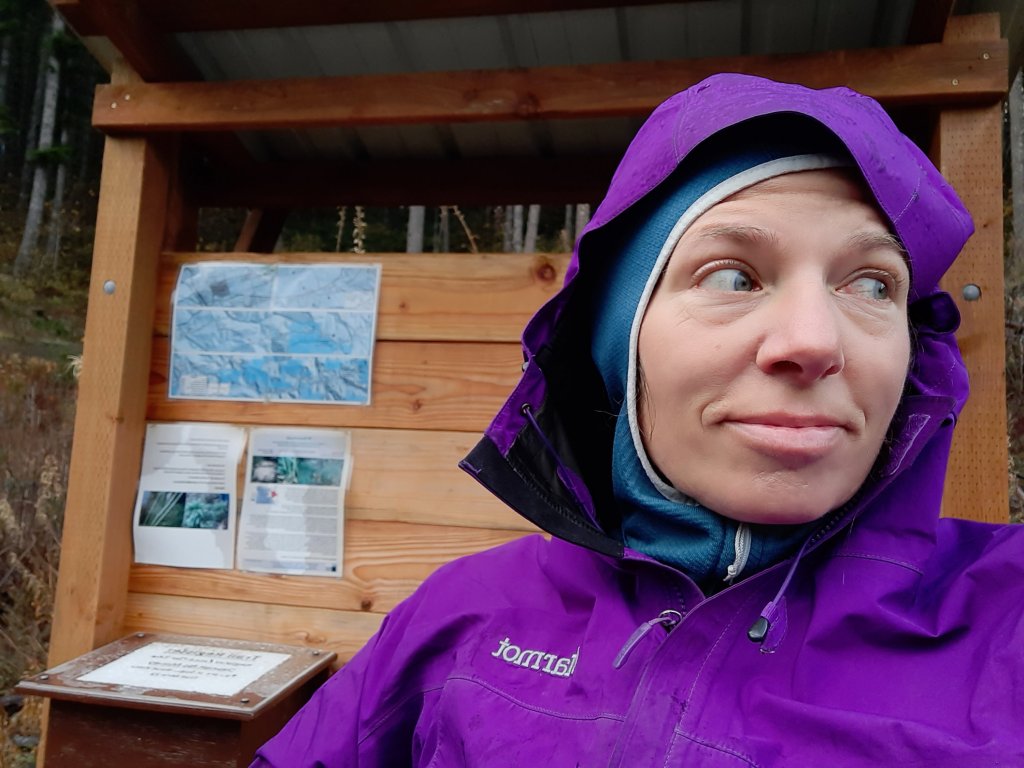
Lunch found us near one of the numerous C2C kiosks that had been installed. They all contain slips to register your hike, but I’d suggest they add a trail register note book so we could read tid bits of those who had come before us, or leave advice of our own, like: “bring more whisky for this section.” (We ran out of whisky today).

Even better for a lunch break? Sun!!! We plopped down in a rare patch of sun and had a glorious lunch and lie-down in the warming light. We have been pretty lucky with the sun on this hike…but then came the hail.

We had walked close to Harlan, a town that time forgot, (a town with no services that is, not a pizza food truck to be found) when a great rush of wind pushed a small hail storm into us. We sought refuge under a giant doug fir tree as the squall passed. 

Later we pulled over briefly to let some traffic pass….30 cows and a few cowgirls on horses that is, and kept walking.

Cows and cowgirls

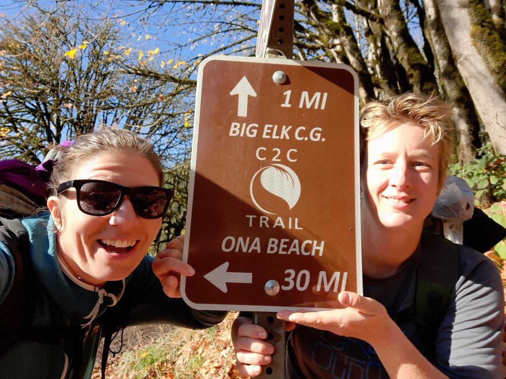
On and on, and on and on. We plod up the road (plenty of road walking today, but also lovely little stretches of trail) and decide to skip checking out Big Elk Campground (the half way point!) and decided to make a few more miles before stopping for camp. 

We turned onto some new trail construction and got a few liters of water for the night at a stream crossing before climbing up the many switchbacks to the ridge above. The next section of trail paralleled a road, and after we crossed the road and climbed up and the road stayed level, posited that the road may be a less “oofta” inducing experience. 

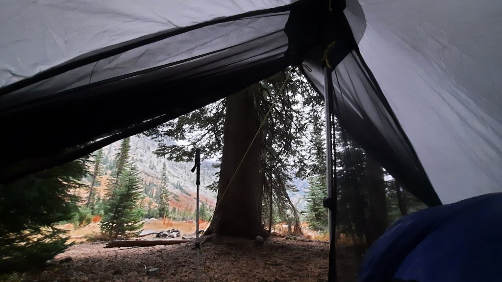
Aches and pains update: my legs feel like lead weight and my feet are angry. Amber reports feet feeling like hamburger (echoing a comment I made at one point yesterday), and sore shoulders. Since I am writing this in the dark early morning of the next day, she also adds “my neck hurts because I can’t sit up in my tent and have to hunch over. ” Note to Amber: get a new tent.

We made camp right before another heavy rain storm unleashed the wet from above, but we are buttoned up warm and dry to welcome another 14-hour night.

Corvallis to the Sea Trail: Day 1 – 19 miles

It was February, 2020, BC (before COVID) when I last visited my friend Amber in Corvallis.


This is where I first heard about a new long-distance trail that crossed the Oregon coastal mountain range to the the Pacific ocean.


Amber was doing trail work for the almost-complete 60-mile Corvallis to Sea trail (C2C) and was putting her saw skills to the test clearing trees from the path. Amber and I met in 2007 when we were both training in a trail crew leader development program at South West Conservation Corps in Durango, Colorado. We spent days learning to use chainsaws and cutting down scores of tall pines in thinning projects for the forest service. It was back-breaking work, but we were young and the work was empowering.

Our crew in 2007


When I heard the C2C had a grand opening in August of this year, I sent Amber a text and asked if she would thru-hike it with me. The only time our schedules aligned was in early November, so we braced ourselves for the short rainy days that are typical in late fall in this part of Oregon. 


On a Thursday afternoon I drove over the pass through driving rain to Corvallis. Amber and I spread the contents of our packs across the floor of her living room and proceeded to talk our way through gear choices in what was sure to be a rainy and cold four days.

  
On further examination of the weather between here and Ona Beach, the temps would be in the 50s and 40s, so not too cold, but with 90-100% chances of precipation, we girded ourselves for constant rain.
Friday morning we set out into the dark-almost light of the day from her front door. Amber only lives 2ish miles from the start of the trail in downtown Corvallis, so why not walk out her front door? 
We crossed busy traffic and as the sky lightened we could see color and patches of blue sky. Hmmm, blue was not what we expected, but we’ll take it!

Walking to Corvallis


I regailed her with tales of pain, stress, and heat from the month Kirk and I had spent on the John Day River this summer, and we cruised through the urban part of this trail.
Sidewalks and paved bike paths took us through Corvallis and into Philomath. The benefits of urban hiking became apparent when we took an alternate to Sissy’s Donuts. Sissy herself was at the counter, and as she filled our donut order, took curious looks at our packs.

Sissy


A few minutes later we walked out with a full water supply (it will be a dry camp tonight) and our first trail magic of the trail – two donuts for the road! How wonderful! I told Sissy that she was our first trail angel of the trip, and she positively glowed. Trail community starts with lovely experiences like this! 


Then we went next door to the Dizzy Hen Cafe and ordered lattes. Multiple people stopped to hear about our plans as we soaked in the unexpected sunshine, donuts, coffee, and conversation. This is proving be to a most excellent start to the trip.


We walked out of town and turned right onto Old Peak Road. The pavement-to-gravel road wove through a temperate rainforest of dripping mossy trees in shades of neon green.

One of the many C2C Kiosks on the trail


Next up was a tree-farm part of the route…one of the only sections where you need to get a permit to pass through the private lands of the Starker Tree Farm.
A few gorgeous old-growth trees remained along the road. These mind-bending beauties had trunks so big we just had to stop and take it in. This was a glimpse into a world where the forest had been filled with trees of this size. We would be walking through a visual history 200 years of logging.


The sun was still out. Can you believe it? We had sun the whole day. It was simply incredible and highlighted the golden yellows of fall in the deep green forest. We practically skipped through the forest as if our muffin-tops and legs weren’t sore. These 40ish year old bodies were a bit achy, but also lucky to be walking through the forest on a sunny November afternoon with gifted donuts in our pack. The trail provides. 

Some massive old growth trees, the whole forest had trees this big at one point!


We made camp off a decommissioned spur road, and watched the last traces of day fade from the blue sky. BLUE SKY!

Mountain Wandering: Day 3

Awe won. Hands down. 


Sometime in the night the rain stopped. When the first light opened the day I could see to the cliff sides across the creek; it will be a brilliant day.


I was packed and walking before 8am, excited at what I could already see. Because I took a layover day yesterday, the logistics of some of those loops and lakes were taken off the table, but it is what it is. My back is feeling better, and what I can do is climb up to Horton Pass at 8,500′ and peek over the other side to the lakes basin. I need about 25+ more backpacking trips here to see all that I want to see. 


This area has a strong pull on me.


I hike up and up, the trail isn’t messing around and only has a few miles to get me to the shoulder of Eagle Cap Mountain.


Soon I can see the snow zone. About the last mile to the top will be in snow, softened just enough by the sun to make the going easy.

I’m glad I wasn’t up here yesterday. 


This is simply astounding. 


There are no other tracks, no other signs of humans, I have the world to myself today. Up top I am greeted by ridgelines shrouded in cloud wisps, lakes and snow and trees as far as the eye can see. 


After just a few minutes I turn around and gingerly follow my footprints in the snow back down down down to Eagle Creek below.


From here I just need to decide where to camp. I am due to stay with Mike and Donna Higgins in Halfway tomorrow night, but the forecast has me a bit nervous for tomorrow. Rain is coming, snow in the high country. I drove my little Honda Fit out here, and accessing this trailhead alone had me at high elevations on gravel roads. I don’t want to get stuck, so I debate camping close to the car so I can make a mad dash if the rain/snow materializes early.


As it is, I find myself mulling over what ifs and maybes all the time, especially when I’m out by myself. Planning ahead and preparing for the worst is one of the best things you can do out here. If you are prepared for the worst, everything else will be delightful! It’s very much on my mind as I am hosting a conversation this week (October 14 on Zoom – 5pm Pacific time) about safety and risk and being prepared for a backcountry adventure. I’ll be talking with two people who were on different sides of search and rescue efforts: Stacy, who broke her knee while on the Oregon Desert Trail and needed to call for help, and Tomas who found and unconscious man and needed to provide help. Should be a good talk!


So I walk out, slowly, savoring the colors and granite and marble mountains. 


I am super close to the car, and can’t find a good spot to camp, so without really thinking about it walk right back to my car. It’s car camping time! I set up diagonally across the back of my Honda fit and manage an ok night of tossing and turning. 


This was a short and sweet little hike up into the heights of NE Oregon, and it only leaves me wanting more.

Mountain Wandering: Day 2

I thought I would give the day a head start and lay low this morning. The rain started as I was finishing my coffee and made the decision for me.

Thanks for the pancakes Charlie & Emelie!


I had 2,500’ish to climb in 3 miles. If this rain is snow up there, it could be a mild snowfall or a blizzard. Both are likely. I’ll check it out later after a morning nap.


While laying about, listening to rain drops splashing off my tent, I put on an On Being podcast episode. The topic was trees with Suzanne Simard. Suzanne did the science that proves all trees are connected, and further posits that humans are a part of that connection. 


I’m working on reconnecting presently.


It’s 10:30 am and the rain has only gotten heavier. I asked for a weather report on my InReach to find the forecast is for 100% rain this morning, tapering to 40% this afternoon and 0% over night. Tomorrow, sunny. 


Ok, decided. I dug a moat around my tent to guide the puddles of water formed in the compacted earth away from my dry things, and climbed back inside for some hot cider and reading. Thank goodness the fear I carry is boredom because I have a new book, half a Harper’s magazine and hours of podcasts in my pocket. The not walking will probably be good for my back and foot too. 


Well, the day happened, and at times the rain stopped and I could spy fresh snow above. Tomorrow will be stunning.

Mountain Wandering: Day 1

Can awe overcome pain?


The planter faciatus that I developed on the Blue Mountains Trail continues to plague me. I’ve made attempts (some successful) at solving the piercing pain in the heel of my right foot, but it always comes back. 


Oh, and I tweaked my back this summer for the first time. Kirk and I were up at Elk Lake for his birthday, moving paddleboards to the lake, when I twisted while picking one up and my whole lower back twinged and I had very little movement and a lot a pain. I did it again to a lessor degree last weekend when I tried to get out of my tent. 


Both are plaguing me on day one of a 4-day solo backpacking trip into the Wallowas. Maybe I can walk it off? Not likely with the heel pain, especially since I walked that one on last fall.


Ok, it is manage it then…but I’ve got to get serious about healing both. I have a 2-month sabbatical at work next year and I’m going hiking!


So to the awe: this marble and granite chunk of Mountains in NE Oregon (where I started the Blues Mountains Trail last year) is out of this world. I’m hiking (it really feels like plodding) up Eagle Creek towards Horton Pass. The golds and reds from the October fall days are piercing blocks of color against the green and silver rock of the canyon walls. 


A family out horsepacking passes me while I pulled over to eat lunch. They look prepared to set up somewhere for a few days, and when I saw their tracks headed up to Hidden Lake (my intended destination for the night) I found something lower, saving me the 1000′ climb. I’ll take it, for the views at my new camp are already making me forget my worries. 


It was a short day, relatively speaking, but I have no agenda, only loose ideas, and there are countless options for trails, and lakes, and passes, and loops, so I’m just going to take it as it comes this time. No imposing my will on the miles, instead, letting the Wallowas (and my body) impose their will on me.

Develop your personal connection to the desert, and do some work!

I’ve been working hard over the last seven months to revamp the Oregon Natural Desert Associations Independent Stewards Program and all that hard work is starting to pay off! I just launched a few more projects this week, and we have plenty of opportunities for folks to go adventure and preform some important stewardship or monitoring tasks on their trip.

The Source (a weekly paper in Bend) just published a nice overview of the program.


ONDA’s Independent Stewards Program 

Volunteer projects designed for individuals or households to safely undertake during the pandemic

BY DAMIAN FAGAN

This past year was a rough one, even for volunteers. Many nonprofit organizations canceled group volunteer projects to minimize exposure during the pandemic.

One local described that experience.Monitoring in the Spring Basin Wilderness in Eastern Oregon. - MARK DARNELL

  • Photo by MARK DARNELL, Monitoring in the Spring Basin Wilderness in Eastern Oregon.

“I tried to volunteer last year, but COVID derailed that,” said Jess Beauchemin, a volunteer with the Oregon Natural Desert Association. This year, she’s signed up to do monitoring of Wilderness Study Areas in the Prineville District of the Bureau of Land Management.

With risk levels changing, the curtain is partially lifting, and ONDA is ramping up its Independent Stewards program.

“We’ve had an Independent Stewards program since about 2015,” said Renee Patrick, Independent Stewards program coordinator. “But it’s been a very small part of what we offer and wasn’t very well developed with resources to really help people feel comfortable going out by themselves to do stewardship or monitoring work on their own.” With that, ONDA’s Conservation and Campaign staff members began to explore options for utilizing volunteer help with on-the-ground projects, but in a different capacity than the historic group outing. “We went back to the beginning and dreamed big,” added Patrick.

The staff created projects that would be rewarding and engaging to volunteers and could be completed on a flexible schedule. The stewardship team then spent five to six months building out the projects with partnering land management agencies, drawing up maps and collating project information. “We are even doing video tutorials and some of the projects have introductions from our agency staff explaining how the work will impact the on-the-ground aspect to a location or contribute to some greater goal,” added Patrick. The goal was not just to create work projects, but to also relate these projects to the greater context of ONDA’s conservation work and the protection of wild places in the high desert.“To develop a deeper relationship with a place you’ve got to spend some time there.”—Jess Beauchemintweet this

ONDA launched its online volunteer registration form in late February, garnering over 350 interested people. The registration form provides ONDA staff with information about the volunteer’s interests, availability, and even details such as comfort levels with remote camping, backcountry navigation or four-wheel driving—often major aspects of working in hard-to-reach places strewn across the desert. The goal is to match volunteers with the right opportunity.

Available projects revolve mostly around habitat and recreation monitoring, wildlife monitoring and stewardship projects in various locations such as Wilderness Study Areas in the Prineville BLM, Steens Mountain, Fremont National Forest, Alvord Desert and other spots in eastern Oregon.

One such project is the Fremont National Recreation Trail Work/Monitoring project, where volunteers adopt a 1-mile section of the NRT to do some light trail work and to record visitor use with the Recreational Impact Monitoring System app, developed by the Colorado Mountain Club and adapted for ONDA’s work in Oregon. Another trail monitoring and stewardship project will focus on about 40 miles of trail through the Steens Mountain Wilderness.Juniper Mountain lek monitoring. - JIM DAVIS

  • Photo by JIM DAVIS, Juniper Mountain lek monitoring.

Through ONDA’s partnership with the Burns BLM District, staffers learned of unprecedented use of the Alvord Desert WSA in 2020. BLM staff related that the Alvord Desert was seeing impacts caused by three to four times what normal use was in previous years.

“Stewardship activities on the Alvord Desert will include dispersing fire rings (which are a safety hazard especially to vehicles, airplanes and land sailors), picking up trash, brushing out vehicle trespass incursions (beyond the allowed motorized use area), monitoring for negative wildlife interactions and handing out wag bags with included responsible recreation information,” said Lace Thornberg, ONDA communications manager.

“I spend a lot of time hiking in the desert, and I’ve gained a great appreciation of the high desert in the last five years that I’ve lived in Bend,” said volunteer Beauchemin. “This project gives me an opportunity to give back to the organizations that protect the lands that I like to recreate on, and I get to fulfill a deeper relationship with a place that I haven’t spent a lot of time in.”

Beauchemin has committed to visiting sites, twice per year, over the next three years, to provide some continuity even post-pandemic. “To develop a deeper relationship with a place you’ve got to spend some time there,” added Beauchemin.

ONDA
Onda.org/independent-stewards/

Hellraiser Keynote Speech

I was thrilled to be asked to give the keynote speech at the May 8 fundraiser for the Greater Hells Canyon Council. The evening was a smashing success, and raised many thousands of dollars to support their work to connect, protect, and restore the wild lands, waters, native species and habitats of the Greater Hells Canyon Region in north eastern Oregon (and establish the Blue Mountains Trail!)

The speech was recorded ahead of time and you can now watch from the comfort of your couch, lawn chair, or tent (if you are so lucky.)

Join me and Luc Mehl for a Livestream Packraft Conversation

You may have heard about a new packrafting book on the market: The Packraft Handbook by Luc Mehl

Gear review website Treeline Review (and small business owned by two incredible women, friends, and thru-hiking powerhouses: Liz “Snorkle” Thomas, and Naomi “The Punisher” Hudetz) asked me to interview Luc on Tuesday, May 5 to discuss how to get started packrafting.

Here’s the video:

The By Land Podcast & My Latest Logo

My newest logo is out! I am so lucky to have the opportunity to design the new Blue Mountains Trail logo.

BTW, don’t forget the Greater Hells Canyon Council May 8 Hellraiser is coming up in a few weeks, and there tons of awesome stuff going on with the event, but what can be better than helping to support and fund the newest long-distance trail around? Not much IMO 🙂


Back in 2018 I sat down with Emory from the By Land Podcast to talk about the Oregon Desert Trail. Our conversation ranged far beyond the route, and I really enjoyed the conversation, and think you will (did?) too.

Today he published the latest conversation we had about the Blue Mountains Trail, and again, the talk is far-ranging.

Give it a listen when you have a chance!