I had a lazy morning. The rain was supposed to let up about 11am, and having sun for my cross-country descent into Joseph Canyon would make my hike infinitely more enjoyable and safe. Joseph Canyon is a crux in the hike, and if I can find the right route down, should be able to quickly cross it and find myself on an old road that switchbacks up to the rim above.
Don’t get be wrong, I would LOVE to spend some time in Joseph Canyon, but word of copious amounts of poison ivy is already making me itchy, and I haven’t even gotten there yet.
Kirk and I packrafted a 40-mile stretch of the Minam River (a river on the NW side of the Wallowas) a number of years ago with Grant, the owner of the Minam Store. When I heard about the epic bushwhacking, I called up Grant because he had mentioned multiple trips in Joseph Canyon. Turns out he’s hiked into the canyon several ways, and I put him in touch with Jared to figure out some other options for me to hike.
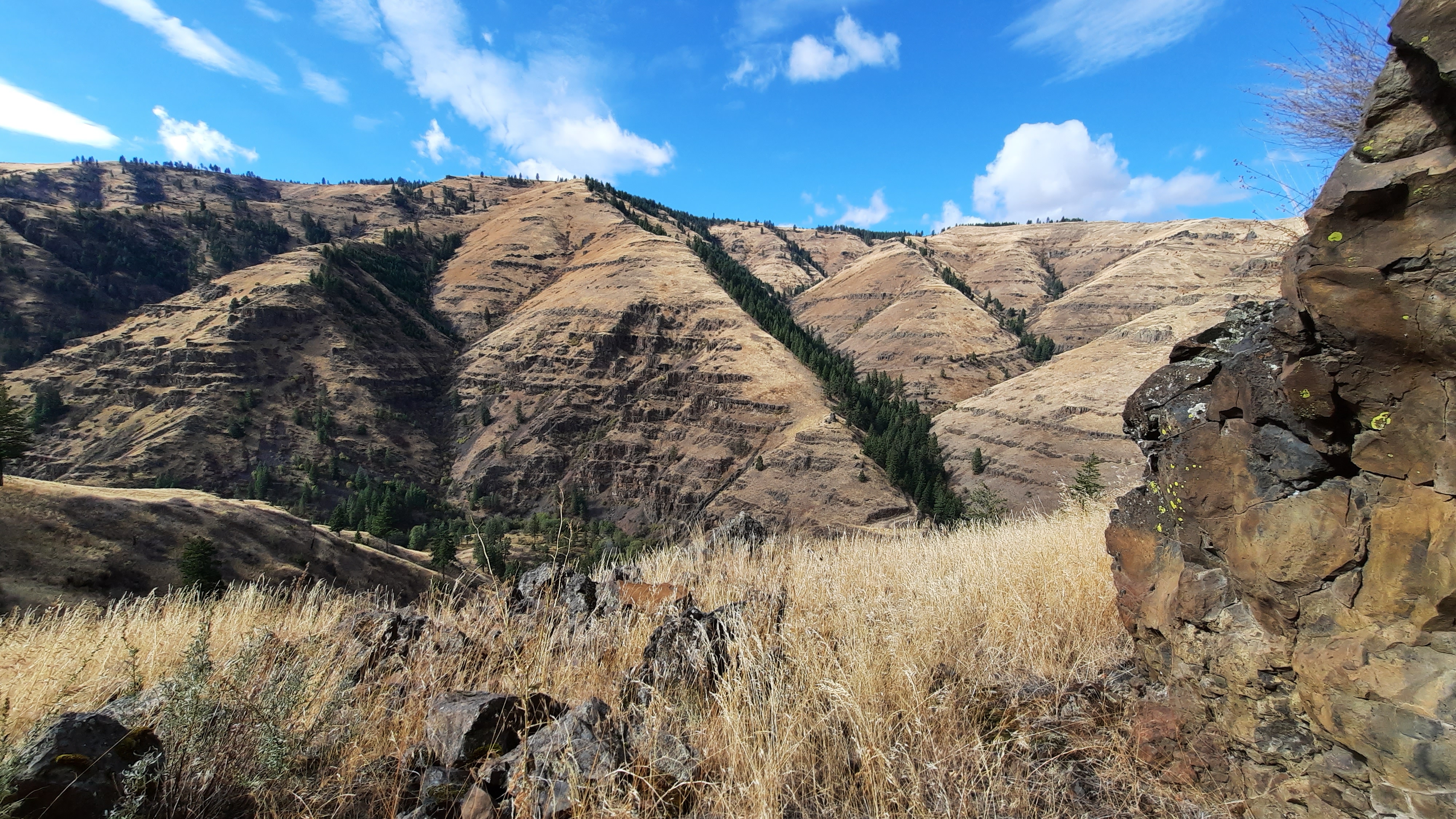
This morning by the time I finally decided to hike, I was already on the edge of Joseph Canyon. I could look straight up the canyon to the Wallowa Mountains and their new snow caps. This is all Nez Perce land. I would be walking into the canyon where Chief Joseph was born.

I dallied on the way to the descent, taking photos and trying not to worry too much about getting into the canyon. My first move would be to walk a mile on a ridge via a “gap” in the rim rock…I didn’t see the gap, but when I saw the ridge I got really excited. I could do this. The next move would be to choose the right ridge to hike down to the water. Whatever way I took it looked like I would need to navigate around some rocky cliffs, but the line I could see had openings, so looked doable.
The wind was fierce and strong, but the sun was out, and I buttoned up the hatches and got started.

The ridge, or knifes edge, or cat walk….whatever you want to call it, was amazing. Probably the best part of the hike so far. The view into the canyons was stunning, and there were plenty of spots to safely stop and enjoy everything that surrounded me. I did have my mantra going on: one step at a time. Be intentional.
I crossed over to the end of the ridge and started down what I thought was the right shoulder….it was open and got steep. I took small steps and made sure something was planted before taking the next step. At some point I realized I was going down a different ridge than I had scouted, but it seemed to go, so I did too.
Ugg, cue the “Hello! Wake up! Time to make another decision!” voice in my head, but no. I kept walking.
It got steep. Real steep, and I finally realized this path did not go. It ended in cliffs. I looked up and over to the ridge I wanted to be on, and decided I needed to climb up to get over. And of course, game trails saved the day. I found a path some loping deer probably took, and gingerly made one step at a time on the steep side hill before I got to the correct ridge and to relative safety.
I don’t think i was ever in danger, I’m just disappointed that I didn’t pay attention when I needed to. However I do not think everyone will be game for such a descent, and definitely not had it been raining and the grasses and mud slick. 100% no!
Down at the bottom I walked up to an abandoned camper trailer. How in the world??? There was a road that I would walk out of here, but whatever road had been in the bottom of the canyon was washed out. And it made me a little sad there was a road at all…thinking of the thousands of years of lives that had probably enjoyed this spot before the modern age bulldozed a road thousands of feet to the bottom of this special place, hauled in a camper, and left it. The windows were smashed, the trailer was junk.

I walked upstream to find a way to cross, and finally just walked in the water with everything on to the other side and found the road I would walk up.
I took a break before the long climb to the top. Had I to do it again I’d spend a night in the canyon.

Up top I popped out at the Rimrock Inn. Closed. Kirk and I had stayed at the Rimrock Inn eight years ago on my birthday. We slept in teepee on the edge of Joseph Canyon after our first packrafting trip on the Minam River. I remember a wonderful steak dinner, wine, and a special birthday dessert. But now they were closed. I am getting to the point where I need to bathe something fierce, and had held out hope even though the website was down when I checked if I could stop and stay.
I walked. I walked through the very quiet town of Flora. More buildings were fallen-down relics of a previous prosperity than not. It was strange and beautiful.

I walked a while longer and found shelter in a stand of trees. Tomorrow, Troy where I hear there is a laundromat and that’s it. I’ll take it!!

Was the road you walked on your way out of Joseph Canyon the one you wanted to walk? Hope Troy was all you’d hoped for…
Friend, Mike
LikeLike
Pingback: To Thru-Hike Is To Go Home – She-ra Hikes
Pingback: To Thru-Hike Is To Go Home – Hike Mike