When I began to develop the Oregon Desert Trail, one of the important tasks I started to undertake was to connect with some of the private land owners who had parcels on or near the route. While the ODT is primarily on public land, I wanted the people living near it to know who these homeless-hippy types were that they might encounter in the middle of the desert.
County data shows where the private land is, and when I found my favorite app, GaiaGPS, offered a private land layer, I discovered I could easily research who owned what along the route.
Most of the 200-miles of the ODT in the Owyhee Canyonlands region is public land, but I discovered a few small pieces of private in there. When I was researching one particular plot in the West Little Owyhee River near the main confluence of the river, I discovered the owner, David Rumsey, was a big-time map collector. So big in fact, that he had a map library at Stanford University named after him. Wow. I contacted David to give him an update on what I was doing with the ODT, and he responded…offering that hikers were welcome to pass through his land to access the river, and even camp there if they needed. (Note: I’ve been finding a lot of generous land owners along the route who offer hikers access to important resources like water and camping on their private land)
David also explained that he got lost in the Owyhees in the 1970s and it completely changed his life.
I wrote up a story for ONDA’s blog about David’s experience, and I think you might enjoy it too:
An Owyhee Mis-Adventure Inspires Life-Long Mission
When a young David Rumsey’s car broke down in the far reaches of the Owyhee Canyonlands in the late 1970s, he didn’t have any of the devices we’ve come to rely on today. No GPS, no smart phone, no satellite locator beacon.
Rumsey had a map, but at the time the USGS 1:250,000 scale only outlined the vaguest of features. Nearly a decade would pass before a detailed USGS map of this remote area would be published. He had to walk out, unaware of the deep canyon walls and boulder-choked rapids that loomed between him and rescue.
“The nearest habitation was fifty miles ahead of me but only reachable by walking through a roadless wilderness, following the road back out would have meant walking almost twice as far, so I chose the more direct, though uncharted path,” Rumsey explained in the forward to his 2002 book, The History of the American West in Maps.

“It is daunting to look out over a fifty-mile vista and realize that one’s life depends on dead reckoning and that the route one takes is based mostly on hope. Walking those miles was the most frightening event in my life and my closest brush with death. As I stumbled late at night through the silently beautiful landscape, I gained an admiration verging on awe for the explorers who had had no maps at all to guide them.”
The arduous four-day excursion to find his way out of this remote corner of the high desert turned out well in the end. It also ignited a passion.
When detailed maps of the Owyhee region were finally available in the mid-1980s, Rumsey “…filled an entire wall with 1:24000 maps so I could visually re-walk my escape whenever I liked and see the location of my rescue. Maps became the mnemonic devices I used to recall the uncharted wilderness that had changed my life.”
Over the next 25 years, Rumsey collected upwards of 150,000 maps. Many of these maps focused on the American West including early non-Native explorer’s maps of the western territories, maps created by trappers, military expeditions and scientific surveys. His quest to visualize the deep canyons of that experience led him to amass one of the largest map collections in the country.
Today, many of Rumsey’s maps can be found on his free digital portal to the collection, the David Rumsey Historical Map Collection or at Stanford University where they are housed at the David Rumsey Map Center in the Stanford Library. He is also collaborating with the Library of Congress on the map division of its American Memory website.
When a reporter from The San Francisco Chronicle asked him Why?, Rumsey responded, “Some people might think [historical maps are] an arcane subject, but I disagree. Everyone can relate. Everyone is curious about where they live. And every map is like a little snapshot of history; each is a visual history.”
In this case, a visual history that started in Oregon’s remote and iconic Owyhee Canyonlands.
David Rumsey has since purchased a piece of land in the Owyhee region along the Oregon Desert Trail near 5 Bar, the confluence of the West Little Owyhee and main Owyhee river, and generously offers passage through his land to ODT hikers in the area. We are jealous of his view.
Story by ONDA’s Oregon Desert Trail Coordinator Renee Patrick.
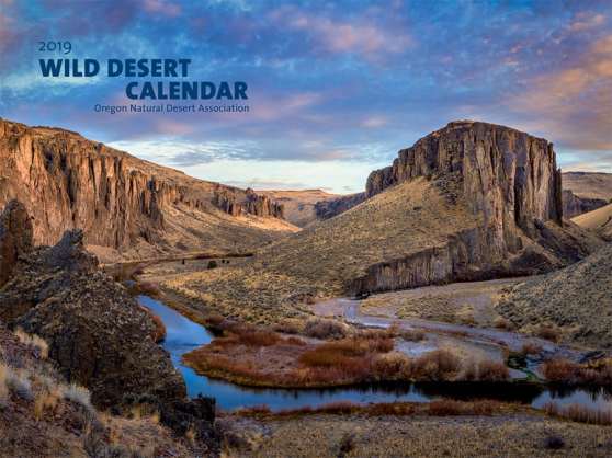
This photo of 5 Bar taken by Devin Dahlgren graced the cover of ONDA’s 2019 Wild Desert Calendar.

Thanks for sharing this great story.
LikeLiked by 1 person
omg, is that photo of 5 bar david’s view?! renee, your story was amazing, thank you for highlighting this man’s incredible contribution!
LikeLiked by 1 person
That image is pretty close to where his land is. Pretty incredible stuff!!!
LikeLike
Fantastic story. I just visited the digital portal for David’s map collection. It is phenomenal. What a life he has had. Thanks, Sheraaaa for introducing us to David Rumsey! And thank you, David, for your generosity for both sharing maps and the land.
LikeLiked by 1 person
I think you published this before but it is SO worth a second read. Thanks.
LikeLike