Last night I had climbed up on the arm of the potentially sketchy game trail portion of the problem area and cowgirl camped in a flatish spot. There was a slight downhill tilt to the area, so I put all my extra gear on that side so it would block me from sliding into the dirt. I bet of all my nights outside a good quarter of them are in less than ideal spots. In this case the benefit far outweighed the tilt for I had an incredible view of the Owyhee reservoir.

The night was incredibly quiet and still. Once the waxing half moon set the stars gave any planetarium out there a run for their money.
In the morning I ate my cold soak oatmeal (a Katie Gerber idea… she is a nutritionist who is currently hiking the ODT with my good friend Allgood and another lovely thru-hiker I know, Swept Away.) It’s my goal to find them after my hike this week and bring them treats.
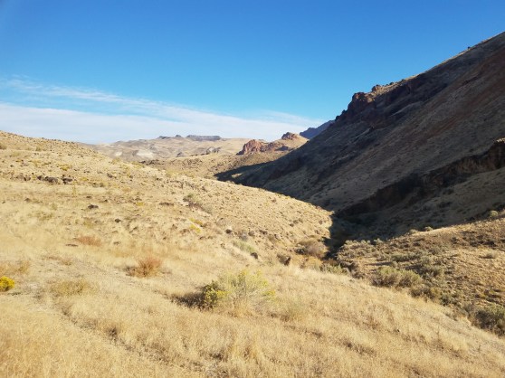
I headed up the trail that looked more legit than just a game trail. I bet people from Leslie Gulch hike up here to check out the canyon. I went slow and reminded myself of my CDT mantra: one step at a time. Each time I rounded a rocky outcropping I saw the path continued, but it most definitely was a game trail by about half way through. The earth was dry and crumbly and I had to be intentional with many steps, although some sections were in great shape. As I neared spring creek the going got tougher and at one point I was downright scared as I had to cross a steep washed out section… I sat down, braced my hiking pole on a rock below me and willed my feet to stay put as I tried for purchase to cross the void. I was sweating a little. But all went well to the bottom of the next drainage. The high game trail goes, if you don’t mind one hairy section. From water level again it looked easier to walk the steep edge of the water than it had from the other side, I’m pretty sure Allgood and crew crossed this low way two weeks ago.

Spring creek was running, and I crossed over it to walk the muddy banks of the water to my next landmark, Willow Creek.

The guidebook advised to stay higher on the west side of the drainage, but I walked up the middle following the braided cow trails that had pushed trails through the brush. After a while I decided to go up as the canyon narrowed, and spent the next 2+ miles up and down, on cow trails and off. Nothing terribly difficult, just taxing. The upper end was choked with willows and a few bigger trees, and the canyon was lined with incredible rock formations.
I met up with a dirt road next. Relief! I freaking love walking on an easy dirt road after an arduous cross country morning. I took a short break in some shade and switched to my chacos for some blissful road walking.

I got to the turnoff point for the alternate route I had wanted to connect with what Becky and I had hiked yesterday, but it looked narrow, brushy, and exactly what I didn’t want to hike at the moment. Seeing it now in person, I doubted this side of the alternate would work, but I do think a higher elevation option could do the trick. I know I can get some good detail on Google earth as I could see a way up (or down) from my vantage point, and from looking closer at the topo maps, think it could be doable. I just didn’t have the energy to climb a few thousand feet to scope it out all the way.
I continued on and had lunch in the shade of am incredibly large sagebrush. Next was a fabulous spring that was pouring cold clear water into a cattle trough. Yum! I tanked up and took 6 ½ liters which would have to get me to tomorrow’s night camp some 20+ miles away. Not a huge water carry by ODT standards.
I trudged up a break in the Rimrock and took a moment to take some photo monitoring images in a narrow pinch point in the terrain. This year I’m getting some baseline photo data for places on the trail where hikers are funneled through the terrain. I want to gauge if we are having impacts on cross country sections within Wilderness Study Areas along the route. In this instance I was walking on a well defined cow trail…and the evidence was all around. Cow pies of various ages, and grasses chewed within inches of the ground. No sign of hiker impacts. We’ll continue to get photos from about 20 different spots along the route each year and see what is happening. So far, the cows have a dramatic impact, hikers, none.
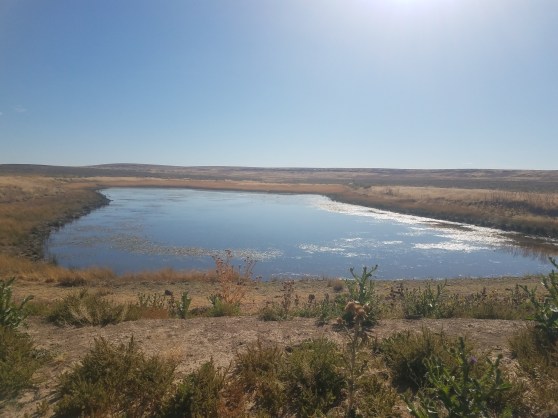
The top of the Owyhee Canyon is flatish and dry. I hiked cross country by a few dirt reservoirs, two with water, one with cows, and a couple dry ones. The rest of the afternoon was on two track dusty roads before I pulled off at a viewpoint down into the Birch Creek area. I’m far enough away that I can’t quite tell what I’m looking at, but it’s gorgeous!

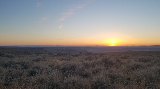
Oh! And I can see the Steens from here! The unmistakable Kiger Notch marks the presiding hulk of the 50-mile mountain over the rest on the Oregon desert. That’s only about 300 ODT miles from here.

This is aweesome
LikeLike